Biking on Nantucket Island
- uniquejt
- Aug 7, 2023
- 4 min read
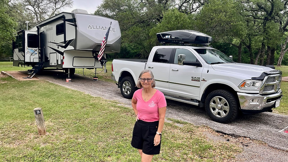
Our last day in Plymouth was planned. We wanted to see Nantucket Island and some of Cape Cod so we got up earlier than usual and drove to Hyannis Port to catch the fast ferry. Hyannis is a village on the Cape Cod peninsula in Massachusetts. It’s known for beaches like wide Kalmus Park Beach and the private Kennedy Compound at nearby Hyannis Port. The John F. Kennedy Hyannis Museum chronicles the assassinated U.S. president’s family vacations through videos and photographs. At the harbor, the Cape Cod Maritime Museum has boat-building exhibits. Ferries connect Hyannis to Nantucket Island. We paid to bring our E-bikes over to the island so we could get around at our leisure.
About 30 miles off the coast of Cape Cod, Nantucket beckons visitors to experience its coastal beauty. Just 14 miles long, the crescent-shaped island is easy to explore by bike and the island shuttle buses have bike racks. Nantucket is home to just one town and two zip codes, and many of the restaurants and shops are located downtown in Nantucket proper. We chose Nantucket over Martha’s Vineyard.
Martha's Vineyard is located closer to the mainland, only 7 miles offshore across Vineyard Sound. With about 125 miles of coastline, the island comes in at close to 96 square miles, about twice the size of Nantucket, making a car more of a necessity. The town’s population soars from 17,000 to close to 200,000 in summer — about twice the number of seasonal visitors to Nantucket.

The trip over took an hour and when we arrived I couldn't believe the crowds of people, cars and trucks! It was crazy; Karen and I couldn't wait to get out of the downtown area. I can only imagine what Martha's Vineyard would be like! We ate lunch then headed west out of town towards Jetties Beach. This location was on the windward side that day and the water was rough, but the swimmers and sunbathers appeared pretty content. From there we turned south and rode across Nantucket's width to the leeward side of the island to Surfside Beach. The scenery was pastural with the interior of the island relatively calm but plenty of road traffic so we traveled the bike routes when available.

Our next stop was via Surfside Road to Milestone Road bike trail and on to Siasconset on the eastern most end of the island. With the roar of the nearby surf muted in the background Siasconset has it all. Just don't call it "sigh-a-skonset" or they'll know you're a mainlander; it's simply pronounced "skonset".
The area was settled as a fishing village in the 17th century. The core of Auld Lang Syne, one of the older fishing shacks, is believed to date back to the 1670s, potentially making it one of the oldest houses on Nantucket. Various other cottages date from the 18th and 19th centuries. Many of the houses were haphazardly expanded, contributing to the unique look of these Nantucket cottages.
In the 19th century a whaling station was present in the village. In 1877 Edward Underhill from Wolcott, New York, bought land in the village, and constructed new cottages in the fashion of the original fishing shacks, and then rented them to summer tourists before they were sold upon his death.


We decided to take a different route back to the town and rode the Polpis Road bike route. This bike trail took us by a golf course with a wonderful view of the Sankaty Head Light, a lighthouse located on the east end of Nantucket island. It was built in 1850, was automated in 1965, and is still in operation. It is located at the easternmost point of the island, in the village of Siasconset. It was one of the first lighthouses in the United States to receive a Fresnel lens. The tower is 60 feet (18 m) high; its lower portion is constructed of brick, and its upper part is granite. Originally, the light's turning mechanism was powered by a weight-driven brass clockwork,
A brick house was built next to the tower at the time of its construction to house the light keeper's family. In 1887 this house was torn down and a new structure was built. Renovations to the tower at the time included installation of a new lantern section, adding some 10 feet (3.0 m) to its height.
In 1933 the light was electrified, and the mechanical works to turn it were taken out of service. Its original lens was removed in 1950, and is now at the Nantucket Whaling Museum. The light was fully automated in 1965.
In 1987, the lighthouse was listed on the National Register of Historic Places as the Sankaty Head Light. The 'Sconset Trust acquired the lighthouse in 2007, and had it moved away from the eroding bluff (approximately 400 feet) in October of that year.

We arrived back into town around 6 PM and started looking for a place to get dinner. Our choice was the Nantucket Lobster Trap Restaurant for seafood, of course! After eating, we headed to the ferry terminal for the return trip back on the "standard" ferry. This last daily ferry back to Hyannis included bikes, cars, trucks, semis and passengers. It would be a 2 hours and 15 minute trip but we were in no hurry; we both took a quick nap on the crossing back. This was another full day of activities and 30 miles of biking.


Still in the land of childhood memories! My grandparents had a place on Craigville Beach (West Hyannisport) and we would vacation on the Cape each summer. Fond memories. We used to wave to President Kennedy when he flew over to/from the Kennedy Compound and he would often wave back! Thanks for the pics!