Search Results
343 results found with an empty search
- The Land of Spuds and Beyond
188 miles from our Salt Lake City Harvest Host was our next stop on the Snake River in Idaho. It only took three hour and one fuel stop to arrive at Village of Trees RV Resort in Declo, ID.. After checking in we proceeded to our pull-through site A-5. My afternoon was spent trouble shooting our Lippert auto leveling controller. The display screen had gone blank and I had no idea why. After calling Lippert, I removed the display to access the power plug and disconnected the unit for 30 minutes. This is how you re-boot the unit and sure enough it worked! Before leaving the next day I enjoyed a Happy Camper breakfast of hash browns, two eggs with two slices of bacon and one pancake for the bargain price of only $8.99. It included a cup of coffee or hot chocolate too! We stopped enroute at a Blue Beacon Truck wash outside of Twin Falls to get both the truck and trailer a commercial wash job. We had never used this service before so we didn't know what to expect or how much it would cost. We got in line behind two semi-trucks and a van and waited our turn. About 40 minutes transpired before our turn. I was quoted $75 for both and we pulled into the wash bay for the cleaning. A small army of technicians proceeded in spraying down the rigs and brushing them down. The whole process took maybe 15 minutes max. When we pulled out I stopped to inspect the job and was literally amazed at how good the results were. Before the wash our RV front cap was covered with dead bugs and the rear of the rig had a heavy dirt layer. After the process everything was cleaned off and a clear coating of RainX was applied. Definitely worth the money spent. Thursday, July 24 we drove to the Y Knot Winery in Glenns Ferry, Idaho to spend one night relaxing just south of Boise, Idaho. We thought about maybe playing a round of golf at their 9-hole course but it was too hot. We decided to go to the winery tavern for some wine tasting and dinner later in the evening. Karen ordered a flight of five wines that were okay but not worthy of purchasing a bottle of any of the samples. Dinner, however was delicious and not a disappointment. Karen selected their Idaho Red Trout entree and I chose the Ribeye Steak. We departed Friday morning and headed to Boise for two nights. Finding an RV accommodation in the area was challenging and pricey. We got a reservation at the Boise RV Travel Park near the Costco, so we stopped there first to get some needed items before heading to the park. Unfortunately our site was still occupied so we had to temporarily occupy in a different site for one night and move the next day. It was a bit of a inconvenience but we made it work. We enjoyed the pool at the park and joined our old friends Jack and Judy Rust from Santa Rosa for dinner our second night. We hadn't seen them in eleven years but we picked up our relationship right where we left off. One of the many blessings we experience as we travel is spending time with dear friends and family all over the country. We had a great dinner at the Cottonwood Grill along the Boise River across from Boise State University and there was no lull in the conversation. After dinner we walked the green belt trail from the restaurant in a loop about a mile before saying our good-byes. We will definitely not wait eleven more years before we get together again! Maybe we could do some camping in Idaho together in the future; we'll see. Not much to look at with dry hills and a slow moving river here at Farewell Bend State Rec Area. Sunday, July 27 was our departure from Boise, Idaho continuing our travels to Farewell Bend State Recreation Area across the Snake River in Oregon. Farewell Bend State Recreation Area features a beautiful desert experience on the banks of the Snake River's Brownlee Reservoir. Historic markers and interpretive displays provide visitors with information on Farewell Bend's significance on the Oregon Trail. Farewell Bend State Recreation Area is a state park in Baker County, Oregon, about 25 miles northwest of Ontario, OR Farewell Bend was the last stop on the Oregon Trail along the Snake River where travelers could rest and water and graze their animals before the trail turned north through more rugged country to follow the Burnt River. We have a large pull-turn site near the restrooms with free showers. Right before sunset we tried to take a walk to the day-use area going down to the beach on the river, but the mosquitoes were too annoying, so we turned around and returned to the RV. Repellent is definitely needed! We headed to bed around 10 PM and couldn't help noting how quiet it is here in the park. An occasional train will transit on the other side of the river but no horn, just the sound of the diesel engine. The night sky, when the clouds thin out or disappear, is filled with stars, planets and satellites. Today, July 28 is on the windy side so the mosquitoes will not be as big an issue. Looking forward to a non-driving day to relax, read, write and nap. It's a tough life!
- Gracie's Last 2 Days with us
On Monday, July 21 we left Jensen, Utah and drove 75 miles in about an hour and a half to the Fred Hayes State Park for the night. We were originally scheduled in the Indian loop with no hook ups. After driving through the loop we realized this wasn't going to work. We drove back to the entrance shack and inquired if we had any other options for our one night stay. The park attendant was very helpful and found us a pull-through site in the paved Beach Campground next to the lake with water and electricity for extra $10. This was a no brainer for us and we jumped at the chance. Our pull-through site was long enough for two trailers! Fred Hayes State Park was originally named Starvation State Park, after the reservoir it surrounds. Starvation State Park was established in 1972, two years after the Bureau of Reclamation constructed the dam, which created the 3,495 surface acre reservoir as part of the Central Utah Water Project. The name “Starvation” has been credited to two legends. One says that a group of mountain men caught in winter snow survived by stealing a cache of food belonging to local Native American tribes, and as a result, the tribe starved. The second and more common legend tells the opposite story, with the tribes stealing the trappers’ cache of food and leaving the trappers to starve. It is very likely, however, that neither legend, even if true, resulted in the naming of the dam and reservoir. The weather conditions were a bit windy and it looked like rain. We walked down to the water's edge to get a good look at the facilities. Boaters and jet-skis were on the lake with an occasional wind boarder. If it was warmer I might jump in for a swim but this wasn't the day for that. I did enjoy the night sky here. No light pollution, so the stars were quite visible. June 22, Tuesday was Grace's day to fly out of Salt Lake City Internatioal Airport about 2 hours away, so we got up earlier to pack up and depart. The drive was beautiful and took us through the Wasatch Mountains and past Deer Creek State Park. We came through a pass in Canyon Glen along the Provo River and into Orem, Utah. From there we traveled up Interstate 15 to Sandy, Utah and parked at Sego Lily Church, a Harvest Host. This was our base of operation for Grace's last day with us. We unhitched the RV and set up the rig before leaving for lunch. We found a Jersey Mike's in the same complex with a Scheels Sporting Goods Store. We had to take Grace to Scheels to ride the indoor Ferris Wheel for a dollar. After the ride we did some exploring in the store which is massive. Grace found the Lego area while I examined the $279 Pickle Ball rackets! Honestly, $279 for a Pickle Ball racket? We checked out the aquarium and the stuffed wildlife exhibits which were quite impressive. I was hoping Grace might see a moose during her trip to Colorado and Utah. Well, look what I found hanging out in the store! Real but not living was the best we could manage. Well, the time finally arrived for us to take her to the airport. Traffic was an issue but we got to the terminal two hours prior to her flight time. I had to say my goodbyes from the Departure Drop-off Area while Karen went in to get her through TSA and to her gate. I killed the time drowning my sorrows with a Freddy's Tuttle Sundae! Karen and Grace had dinner at the Freddy's inside the terminal while I ate alone. After a flight delay, Grace was winging her way back to California. We got a call from her after getting picked up by her dad, so we knew she arrived safety back home. We really enjoyed her ten day visit with us. We just wished she hadn't beaten us up at cards so much! It's now back on the road with only the two of us Classy Nomads.
- Dinosaur National Monument
We departed Craig, Colorado and traveled to Jensen, Utah. Our route on Interstate 40 would take us through both the Colorado side and Utah side of the Dinosaur National Monument. Our last stop in Colorado was in the town of Dinosaur, CO to get some information at the Visitor Center. We drove the 110 miles in less than 2 hours and arrived at Outlaw Trail RV Park, our home for the next two days. We enjoyed having full hooks and took advantage of the amenities. We relaxed on Saturday, July 19 resting up for our scheduled visit to the Dinosaur National Monument Quarry site on Sunday. Here's an overview from the National Parks Service website I found interesting: The First People - Dinosaur National Monument is home to a vast and rich cultural history. Since time immemorial, people have lived and migrated through here, drawn by the natural riches of the area. Proximity to the Green and Yampa Rivers provided a reliable water source, while the natural alcoves and canyons offered cool shade and respite from the desert sun. An abundance of archeological evidence, including stone tools, granaries, and homes reveal that people have lived in the area for at least 10,000 years. The presence of petroglyphs (etchings) and pictographs (paintings) on the rock faces throughout the monument show us that life was comfortable and allowed people to devote a substantial amount of time to the creation of these images. Many of the petroglyphs and pictographs found within Dinosaur National Monument are attributed to the Fremont peoples, whose descendants still reside in this area today. We drove through the park and found some of the many petroglyphs (etchings) and pictographs (paintings) on the rock faces. New Arrivals - In the 1700s, Spanish explorers arrived in the region. Descriptions of the area, like those provided in the journal from the Dominguez and Escalante Expedition, helped open the door for others from Europe and the eastern United States. Some of the first European visitors to this area were trappers and traders for the Rocky Mountain Fur Company. In May 1825, a small group of these trappers set out from Green River, Wyoming in search of beaver pelts. They became some of the first to float down the Green River through what became Dinosaur National Monument (they got as far as the rapids at Disaster Falls). Settlers also came to the area throughout the 1800s. Those who had access to the rivers left their mark on the landscape with homesteads. Others dried up with drought and moved away. Today, the remains of many homesteads are found alongside petroglyphs and pictographs. Families of successful homesteaders continue to live in the area. In a remote rock canyon deep in the heart of present-day Dinosaur National Monument, sits a lonely wood ranch house that once was home for a stoic woman with outlaw ties named Josie Bassett Morris, who lived there alone for more than 50 years. This cabin was the home of Josie Barrett Morris from 1914 until 1964 In 1893, at the age of 19, Josie married Jim McKnight, the first of five husbands, with whom she had two sons; Crawford McKnight and Herbert “Chick” McKnight. Sources claim that she divorced four husbands, “allegedly running one off with a frying pan. A fifth husband died, reportedly of alcoholism, but rumors persist that Josie poisoned him.” In 1914, at the age of 40, Josie, with help from her son Crawford, built the cabin at Cub Creek near Split Mountain, about 40 miles east of the town of Vernal. Josie chose a blissfully peaceful spot, building not only a home, but an outhouse, root cellar, chicken coop, tack shed, and hundreds of yards of rail fencing to corral a herd of unruly cows. A small creek that trickled from nearby Hog Canyon gave life to the ranch. Known far and wide as a colorful character, Josie became a bootlegger during Prohibition, making brandy, wine and whiskey. In her 60s she was accused, tried, and eventually acquitted of cattle rustling. She didn’t deny it, claiming it was retribution for the cattle that were stolen from her family, and the charges were dropped. With cast-iron determination and unwavering self-reliance, Josie carved a life out of a place so rugged that few could imagine living there even today. Without electricity, hot and cold running water, neighbors, or any way to communicate with others, Josie typified the endurance of turn-of-the-century Utah pioneering. She tilled, plowed and planted, grew a garden and fruit trees; she tended to the land making it prosper under her solitary care. She lived there for the next 50 years, virtually alone. Dinosaur National Monument - History was made again in 1909, when a paleontologist named Earl Douglass arrived on a mission from the Carnegie Museum of Natural History in Pittsburgh, Pennsylvania. His task was to find intact dinosaur bones and send them back to the museum for display. After searching for many weeks, his team found the first bones of what would soon become the Carnegie Quarry in Jensen, Utah. This small section of the Morrison rock formation would go on to yield over 350 tons of fossils and become one of the most significant paleontological finds of the 20th Century. On October 4, 1915, President Woodrow Wilson established the 80 acres around the Carnegie Quarry as Dinosaur National Monument to protect the enormous find. On July 14, 1938, the park was expanded another 200,000 acres by President Franklin D. Roosevelt. This was an effort to protect the Green and Yampa Rivers, and the ecosystems that depend upon them. We got an early start on Sunday to beat the heat. We arrived at the Visitor's Center where the shuttle transports visitors to the quarry site up the hill about a mile. After our visit to the Quarry site Karen talked us into walking the Fossil trail 1.2 miles back down to the Visitor Center. After a morning of exploration we returned to the trailer to shower and eat a light lunch before heading into Vernal, Utah 13 miles away to do some grocery shopping at Walmart, get some diesel fuel, DEF and dinner. We decided to celebrate Grace's 13th birthday dinner at Swain's Steakhouse.
- Rocky Mountain High
On Tuesday, July 15 we departed Colorado Springs and returned north to Longmont, Colorado to stay at the Boulder County Fairgrounds RV campground again. After setting up we headed to the Johnstown location of the first Buc-ee's west of the Lone Star state. Grace had never experienced a Buc-ee's and we wanted her to get a chance check out this unique Texas style travel center. After an obligitory photo with the Buc-ee's mascot statue we went inside to do some shopping. Grace purchased a pair of Buc-ee's shorts and we made sure to get some of the famous beef brisket and beaver chips for lunch. The biggest Buc-ee's in terms of square footage is the one in Sevierville, Tennessee, which is 74,707 square feet. However, a larger Buc-ee's is currently under construction in Luling, Texas, which will be 75,000 square feet. On Wednesday we went back to Thornton so Grace could get in a visit with her Colorado cousins. Tori and the kids had just gotten back from a visit to her fmily in California the night before. We brought some steaks to barbecue for dinner after Erik got home from work. Grace is as tall as her Aunt Tori now which was a shocker. The boys, Mattis and Arley were enamored with their cousin Grace and stuck like glue to her most of the day we were there. The visit was short, but we had fun getting the cousins all reconnected. The next day we had to start our journey west, so we said our good-byes and returned to the RV in Longmont for the night. Thursday morning we packed up the rig and traveled north on Interstate 25 to Fort Collins, Colorado before turning onto Colorado 14 up into the Roosevelt National Forest and the Rocky Mountains. Hwy 14 follows the Yampa River known for white water rafting adventures and some incredible fishing spots. We drove about an hour up the highway and chose a dry camping site right on the river. The Narrows Campground was picturesque and the sound of the river next to us provided wonderful white noise to drown out any road noise from the highway. Friday morning, July 18 we drove up to Steamboat Spring, Colorado to experience the Old Town Hot Springs facility. The pools have been here for over 100 years. This screenshot was captured from their website. I was too busy enjoying the pools to take any photos. 'The Ute Indians who first settled the area knew them as “medicine” springs, frequenting them for sacred physical and spiritual healing. Later the pools were likely a gathering and bathing place for the first homesteaders. We are lucky to have the famous Heart Spring, the source of all the healing mineral water in our eight pools. It pumps approximately 220 gallons per minute and comes out of the ground like an artesian well, thus naturally without the use of man-made pumps. The water then runs into an overflow system filling each of the pools on the property. The Heart Spring contains all natural minerals and is not chlorinated. The water in the pool turns over completely approximately every 15 minutes. ' After a relaxing hot spring session we drove on to the town of Craig, Colorado to spend the night boondocking at the Yampa Valley Golf Course. We ate in their restaurant and had a wonderful meal before playing cards again. We have had fun playing cards each evening; Grace has been the "The Dominator!!" whether it is Five Crowns or Four up, Four down.
- Travels with Grace
On July 12 we drove to Denver International Airport to pick up our granddaughter Grace Tayler to travel with us until July 22. Grace is the fifth granddaughter to join us on our adventures traveling the country. We wait until their 13th birthday to celebrate this "Right of Passage". Grace has some experience traveling but this was her first solo airline flight from Sacramento without an adult. Her flight was delayed a few hours getting into Denver but it still was early enough to have dinner with her Uncle Erik at his house in Thornton, Colorado. On Sunday, July 13 we attended church then drove south to Colorado Springs for the next two days. We arrived at the Norris Penrose Event Center after a big rodeo event and found an RV site with water and 50A electrical service. The weather in Colorado since we arrived has been in the high 80's and low 90's, so we needed electrical power for the air conditioner to work. We went to our friend Kim Robinson's new home and met her husband Dave Sheets. They were married last May and we enjoyed visiting and catching up. On Monday, July 14 we drove up to Manitou Springs to catch the COG Train to the top of Pikes Peak. The Cog has been climbing Pikes Peak since 1891. They are proud to be one of the most unique experiences in the country. Recognized as the world’s highest cog railroad, The Broadmoor Manitou and Pikes Peak Cog Railway is an important part of the heritage of the Western United States. Taking this journey is like walking the footsteps of history, and now the adventure is even more iconic and inspiring. The weather at the top of Pikes Peak was snow and 55ºF Pikes Peak, known as America’s Mountain, is the star attraction but the journey along the way is full of show-stopping moments. We will never forget this 3.5 hour round trip journey and our first glimpse of the Summit. The next day, before leaving Colorado Springs, we had scheduled a Segway tour of the Garden of the Gods. The area now known as Garden of the Gods was first called Red Rock Corral by the Europeans. In August 1859, two surveyors who helped to found Colorado City explored the site. One of the surveyors, Melancthon S. Beach, suggested it would be a "capital place for a beer garden". His companion, the young Rufus Cable, awestruck by the impressive rock formations, exclaimed, "Beer garden! Why, it is a fit place for the Gods to assemble. We will call it the Garden of the Gods." However, an 1893 issue of the Colorado Transcript reported that Helen Hunt Jackson assigned the name "the Garden of the Gods": Pike Peak is just over Karen's right shoulder. Completely different weather! Our last stop before the end of the tour was for photo with the "Praying Hands" as our background. We explored this beautiful park the fun and easy way on a Segway tour with our tour guide Bobcat. We learned about the ancient history of the park’s red rock formations and got to see how natural shapes like Kissing Camels and Praying Hands got their names. We covered about 5 1/2 miles on our Segway "chariots", much more ground than by walking and had a blast!
- Chimney Rock and Scott's Bluff
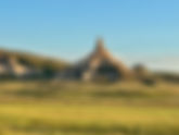
After a breakfast stop at Ken and Dales Restaurant in Alliance, Nebraska we continued on to the Riverside Campground in Scottsbluff, Nebraska for two nights. This break in our trip was to explore two prominent National Monuments that played an important role in the historic westward expansion of settlers and are located in this somewhat remote part of Nebraska. Visible for miles, Chimney Rock was more than a wonder of nature. It was also a significant landmark in measuring the emigrants' progress west. This natural feature was a "grand and splendid object" to emigrants who had never seen the geology of the American West. As they traveled alongside the North Platte River, they peered eagerly ahead for their first view of the rock. It was mentioned in more emigrant diaries than any other landmark on the Oregon Trail! Designated in 1956, the site is jointly administered by the city of Bayard, the Nebraska State Historical Society, and the National Park Service. Scotts Bluff National Monument is located west of the City of Gering in western Nebraska, United States. This National Park Service site protects over 3,000 acres of historic overland trail remnants, mixed-grass prairie, rugged badlands, towering bluffs and riparian area along the North Platte River. The park boasts over 100,000 annual visitors. This feature of Scott's Bluff is referred to as the "Gibraltar of Nebraska". The monument's north bluff is named after Hiram Scott, who was a clerk for the Rocky Mountain Fur Company and died near the bluff in 1828. The bluff served as an important landmark on the Oregon Trail, California Trail and Pony Express Trail, and was visible at a distance from the Mormon Trail. Over 250,000 westward emigrants passed by Scotts Bluff between 1843 and 1869. It was the second-most referred to landmark on the Emigrant Trails in pioneer journals and diaries. Ruts in the trail from the thousands of wagons that traveled this route still exist to this day. The Park Service built a road to the top of Scott's Bluff that provides an impressive and expansive 360º view. Fur traders, missionaries, and military expeditions began regular trips past Scotts Bluff during the 1830s. Beginning in 1841, multitudes of settlers passed by Scotts Bluff on their way west along the Great Platte River Road to Oregon, and later California and Utah. All these groups used the bluff as a major landmark for navigation. Although a natural gap existed between South Bluff and Scotts Bluff, the area was not easily traversed. So initially the Oregon Trail passed to the south of the Scotts Bluff area at Robidoux Pass and the Mormon Trail passed to the north of the bluff, on the other side of the North Platte River. In the early 1850s a road was constructed in the gap, which later became known as Mitchell Pass. Beginning in 1851, this new passage became the preferred route of the Oregon and California Trails; although the Mormon Trail continued to pass the bluff only at a distance. Who built the road through Mitchell Pass about 1850 is unknown, although one possibility includes soldiers from Fort Laramie. Many emigrants preferred this route rather than trying to traverse the badlands on the north side of the bluffs or detouring south to the older trail at Robidoux Pass. Use of the Emigrant Trail tapered off in 1869 after the trail was superseded by the completion of the transcontinental railroad. From the town of Scottsbluff, Nebraska we drove to Cheyenne, Wyoming and then south to the Boulder County Fairgrounds in Longmont, Colorado. The campground operates on a first-come, first-served basis. Reservations are not accepted so we didn't know what to expect. As it turned out, the campground had plenty of sites available with both water and 5oA electrical connections. Restroom and shower facilities are open to all paid campers. At $35 a night we decided this would be our base for the next two days.
- Badlands and Carhenge
Classy Nomad's dispersed site was level and off the dirt road. Buffalo Gap National Grasslands, Nomad View Dispersed Camping was our home after Pierre, South Dakota. The dirt road entrance was off Hwy 240 just south of Wall, SD. We enter where the two radio towers are located and followed the rim road to a level spot down from a small steep hill. The dispersed site rules state that you can only camp in designated camping spots away from the rim's edge. Spots are spacious. We had views of the grasslands/Badlands looking east. We enjoyed pulling our chairs up to the edge of the wall and taking in the views that first night after we got set up for the next two days. Later we would experience some unsettled weather the first night and early morning in the Badlands that included strong winds, gusting to 50 mph, thunder and lightning with torrential rain. The next day we drove the Hwy 240 to through the Badlands to the Cedar Park Visitors Center and Park Headquarters; we took a few brief hikes before returning to get the whole Badlands experience...beautiful desolation. Our spectacular July 7 sunrise and the approaching weather. We departed early on July 7 because of some reported incoming thunderstorms we wanted to avoid. The ground around our trailer got wet enough for us to be concerned about getting stuck, so we made it an early day. The lighting early in the morning and the clouds in the sky made for some beautiful landscape photographs. At 6 AM we had Hwy 240 all to ourselves with the weather behind us. We traveled into the Badlands on Hwy 240 before turning south down a dirt road towards the abandoned town of Conata to Hwy 44. Our route south would take us through some of the more remote parts of the Badlands in the southwest corner and Wounded Knee, South Dakota crossing the border and into the panhandle of Nebraska. Our first stop in Nebraska was to visit Carhenge, a replica of England's Stonehenge located near the city of Alliance, Nebraska, in the High Plains region of the United States. Instead of being built with large standing stones, as is the case with the original Stonehenge, Carhenge is formed from vintage American automobiles, all covered with gray spray paint. Built by Jim Reinders, it was dedicated at the June 1987 summer solstice. In 2006, a visitor center was constructed to serve the site. Carhenge was conceived in 1982 by Jim Reinders as a memorial to his father, who once lived on the farm now containing Carhenge. While living in England, he studied the structure of Stonehenge, which helped him to copy the structure's shape, proportions, and size. It was built in 1987 by Reinders and a crew of approximately 35 family members, and dedicated at the Summer Solstice. Other automobile sculptures were subsequently added to the location of Carhenge, which is now known as the Car Art Reserve.
- Blog Post #300
With our last RVICS project behind us we began our travels south on Friday, June 27 to Aberdeen, South Dakota to visit with Hamp and Marilee Keahey. They were on our team during the February RVICS project in Texas. It was great to see them, do some local sightseeing, meet some of their family, share meals, play games, attend their church and just hang out with them. As of the 2020 census, Aberdeen's population was 28,495, making it the third-most populous city in the state. It is the home of Northern State University and Storybook Land. According to their website, "Storybook Land is a one-of-a-kind destination that transports you to a world of imagination and fun. Your entire family will love the life size characters and interactive scenes pulled right from the pages of nursery rhymes. The Land of Oz portrays the well-known characters and settings of the popular story "The Wonderful Wizard of Oz". Take a stroll down the Yellow Brick Road as you immerse yourself with Dorothy and her friends as you make your way to the Wizards Balloon. Take a ride on the Storybook Land Express Train, Humpty Dumpty Roller Coaster or the Wizards Balloon ride. Explore one of South Dakota's first inclusive playgrounds that offers children of all ability levels the gift of play. Admission is FREE!" From Aberdeen, we traveled on Monday, June 30 to see a rather unusual sight in the middle of the Great Plains. St. Anthony of Padua Church is a historic Catholic church in Hoven, South Dakota within the Diocese of Sioux Falls. Nicknamed "the Cathedral of the Prairie" (though it has never technically been a cathedral), it is noted for its ornate Romanesque and Gothic Revival architecture, the cost and scale of which are unusual for a small rural town. It wa s added to the National Register of Historic Places in 1980 as St. Bernard's Catholic Church. This beautiful church is located in Hoven , a town in Potter County , South Dakota , United States. The population was 379 at the 2020 census . During our stop in Hoven we made lunch in the RV before continuing on. The area, then part of Dakota Territory, was settled around 1883 by German immigrants, and the parish of St. Bernard was established to serve them. The first church, a wooden structure, was completed in 1888, and replaced by another in 1893. The second wooden church was destroyed, along with much of the town, by a windstorm in 1917. Longtime pastor Msgr. Anthony Helmbrecht took the opportunity to construct a brick church inspired by those in his childhood of Bavaria. By the time construction was completed in 1921, Helmbrecht had raised $500,000, enough to build a church with a capacity of 1,200 and decorate it richly. The church's interior paintings and plaster work were extensively restored in the 1980s, mainly at the hands of local volunteers who trained in various restoration techniques and contributed some 20,000 hours of labor. The church continues to rely heavily on volunteers for upkeep. Beautiful stained glass windows depicting the ascension and birth of Christ adorn the church. From Hoven it was another hour to our next campground for the next two days. Left Tailrace Campground at the U.S. Army Corps of Engineers - Big Bend Project, sits on the shores of Lake Francis Case on the Missouri River below Big Bend Dam. Just upstream of Left Tailrace is Lake Sharpe, a popular recreation destination in the Great Plains that was created by the completion of Big Bend Dam in 1966. Big Bend Dam is a major embankment rolled-earth dam on the Missouri River in Central South Dakota creating Lake Sharpe. The dam was constructed by the U.S. Army Corps of Engineers as part of the Pick-Sloan Plan for Missouri watershed development authorized by the Flood Control Act of 1944. Construction began in 1959 and the embankment was completed in July 1963. Power generation began at the facility in 1964 and the entire complex was completed in 1966 at a total cost of $107 million. The hydroelectric plant generates 493,300 kilowatts of electricity at maximum capacity, with an annual production of 969 million kilowatt hours, and meets peak-hour demand for power within the Missouri River Basin. Today, approximately 80,000 acres of public lands and water provide a variety of benefits to the public including flood control, recreation, conservation of natural resources, fish and wildlife habitat, irrigation, and hydropower production. Another great U.S. Army Corps of Engineers facility; this one on the Missouri River in South Dakota. It is possible to view many types of wildlife on the Missouri River at Lake Sharpe. Tribal bison herds can be seen grazing the lake area's grasslands north of the towns of Fort Thompson and Lower Brule. The shoreline areas of the lake also offer excellent waterfowl, upland game birds and big game hunting opportunities. Big game animals include whitetail and mule deer, elk, bison, coyotes and wild turkeys. Waterfowl and upland game birds include ducks, geese, pheasants, prairie chickens, and grouse. Hunting regulations are established and enforced by the State of South Dakota and the Lower Brule and Crow Creek Tribes. The weather has been approaching 100º F, so having electrical hook-ups is a must for our air conditioners. Based on the weather and the upcoming 4th of July we decided to head to Pierre, South Dakota for the next three days rather than disperse camping in the South Dakota Badlands. Pierre (/pɪər/ PEER) is the capital city of the U.S. state of South Dakota and the county seat of Hughes County. As of the 2020 census, its population was 14,091. Pierre is the eleventh-most populous city of South Dakota, and the second-least populous U.S. state capital (after Montpelier, Vermont). Founded in 1880 on the Missouri River, the city was selected to be the state capital when South Dakota was admitted as a state in 1889. Near the center of the state, the then-new settlement was across the river from the settlement of Fort Pierre, and near what became an important railroad crossing of the River. We found a great city park with electricity next to the Missouri River just a mile from the Pierre Capital building. Open year-round and located on the southern edge of Griffin Park next to the scenic Missouri River, Griffin Park Campground features 16 parking spaces that can accommodate all sizes of camping vehicles. Renovated in 2004, each camping pad is built of asphalt chips, has electrical hookups, and is defined by the use of parking blocks. Picnic tables are nearby. A camper dump station is located at the west end of the campground. Potable water is available at the dump station to fill holding tanks between April and November. There are showers, bathrooms, and a storm shelter near the campground, all open from May through October. The city does not take reservations for the campground. It is on a first-come, first-served basis. Campers are asked to fill out reservation cards and deposit them with the required fees in the lock box at the site. Parks staff visit the campground regularly throughout the year. There is a wonderful city pool and water park within walking distance, so Karen can get in her lap swims. At noon on July 4th we went down to the river bank to see a B-1 bomber fly-by. On the 4th of July we viewed the parade in Fort Pierre across the river and later Karen went to the evening rodeo with our RV neighbor Betty from Tennessee. That evening we enjoyed the fireworks from our campsite.
- Powerful winds — including a tornado
This image was taken of a funnel cloud just south and west of our location near Jamestown, North Dakota. A complex storm system wreaked havoc in parts of North Dakota, northern Minnesota and northern Wisconsin, with tornadoes, large hail and strong wind gusts late Friday night (June 20th) into early Saturday morning. Wind gusts measuring 95 to 100 MPH were reported according to the weather service. Friday evening around 10 PM, Adam had all the campers and staff shelter in "the Rock", the utility building on campus with the best tornado protection. We had tornado warnings throughout the remainder of the evening and early morning, so the campers spent the night there instead of returning to their cabins. Cooperstown Bible Camp sustained downed trees and power was lost until Sunday afternoon. The trunk landed between two golf carts just outside the door into the "Rock". At first light the damage to the camp was profound. Just outside the main entrance to "the Rock" was a large, tall pine tree that fell towards the building. The top just slightly damaged the roof and rain gutters. The massive trunk landed between two parked golf carts. Split the trunk of this tree like a popsicle stick. Mike was up on the roof after we removed the tree and started covering the damage with a tarp in anticipation of more rain . The "Nazareth" boy's cabin, took a direct hit from a fallen tree along with the maintenance shop. Saturday morning I led a team made up of four camp staffers in removing the tangled tree debris from the roof. Along with multiple trees down throughout the camp we also lost two power lines downed in the storm. One of the trucks parked near the "Lodge" took a tree limb through the windshield. We thank God that no one here in the camp was hurt. Evidence our Heavenly Father's protection is all around the camp. As for us, we had no damage to our trailer or truck from this extensive wind event, even with our location near a line of trees. There is plenty of tree damage near our site from the wind, even though we didn't experience a "tornado" making landfall. Karen and I played a round of disc golf through the camp and got a first hand survey of the number of trees damaged and downed by the storm. It looks like our last week in camp will involve cleaning up and repairing the damage caused by the storm. Please join us in praying for many hands to clear the downed trees as a new group of campers will arrive Monday afternoon.
- More Cooperstown Woodworking Projects
Monday was a non-working day for me due to a severe cold that zapped all the energy out of me. I spent the majority of the morning and afternoon sleeping in my trailer recliner. I started feeling crummy on Saturday evening and took it easy on Father's Day hoping to bounce back before the beginning of the work week. On Tuesday I started feeling better but still wasn't 100%. I thought: let's try to get out and pace myself. Adam, the Camp Director, but together a "punch list" of projects to work on which included some more woodworking. Karen spent all day Monday and part of Tuesday sanding and sealing some wooden wainscoating in the Ludvig Lodge while I was laid up. Moving slowly, I started on my next woodworking project. The camp has a shortage of portable seating and with the remaining wood from the bunk bed railing project, he was hoping I could build some additional benches. While Karen was working in Ludvig Lodge I put one of the previously built benches in the back of my truck and drove to the maintenance shop to use it as a model for the new benches. I disassembled part of the bench to use the component parts as an exemplar and template for the new bench parts. The design is simple but very stout. Four feet wide, these benches can hold 3 youth or two adults. They are built with a moderate reclining back rail and are remarkably comfortable. They each require about three and a half 2x6x8' boards to complete and are light enough to be moved by one adult. Because of some complex angle cuts, I decided to just use my skill saw and skip using the shop's table saw and chop saw. After tracing out the parts I started cutting and assembling the parts together. I was able to build three benches by the end of the day. Karen joined me in the afternoon and started sanding them down. Wednesday morning we continued building, sanding and sealing the new benches. We only have enough remaining materials for two more completed benches. Adam was so happy with the results he will be driving into Jamestown over the weekend to secure some more materials so we can keep up the production into next week. I'm loving working with wood and power tools...augh...augh...augh...augh! The goal is to build enough benches for the shooting range, archery range and ropes course. If we get enough built while we're here, they will add additional seating around some of the other campfire rings by the cabin complexes.
- Should I cut a hole in the RV slide?
The Alliance Paradigm fifth wheel features a pull-out storage compartment hidden behind the fireplace, providing convenient and discreet storage space. This innovative design allows owners to maximize space utilization while maintaining a clean and stylish living area. The storage compartment is designed for smooth operation, with a simple mechanism for opening and closing. Unfortunately, the Avenue model (which we have) doesn't have this feature despite a large empty space behind the heater. I discovered this space in our fifth wheel after removing the heater to access the wiring when upgrading our CD/radio. The problem was how to access this area in our rig without the drawer feature of the Paradigm. I started researching the possibility of adding a storage door to the outside of the trailer slide in order to access the space opposite the fireplace appliance. YouTube has been a great resource for many of the modifications I have made in the past, so it was the first place I turned to for information. After viewing a couple of videos it appeared to be a do-able project. My first step was to remove the fireplace appliance and move the electrical outlet mounted on the back wall to a more favorable location. A large wiring bundle for the TV, radio and speakers comes into that space and needed to be moved. I zip tied the loose wires and mounted the outlet to the shelf bottom above the fireplace appliance. The next step was a bit tricky. How far above the compartment floor would be the best place to cut the hole in the slide? After taking some measurements on the inside and outside of the space I determined the best location and door size. I wanted to be conservative with the size and opted for a 12 inch by 36 inch horizontal storage door which I ordered from Amazon. When the door arrived last week I inspected it and used the shipping container to cut out a cardboard template of the door. I marked the middle of the template and attached it to the inside of the fireplace slide wall compartment. This allowed me an opportunity to double check the location on either side of the future door opening. At this point I'm trying to think of what else I need to do before cutting through the trailer wall. I know that once I cut through that wall, I've "crossed the Rubicon". My first thought was to drill a small hole through the inside wall in the center of the mounted template. Once that was done I took the template to the outside and aligned it with the hole to level and mark the exterior wall for cutting. Everything looked good so I started cutting through the fiberglass siding with my Dewalt oscillating saw. No turning back now! The key to the process was moving slowly and letting the saw do the work through the exterior fiberglass, foam insulation layer and thin interior plywood backing. With the cutting completed I removed the cut out and clean up the edges for a test fit of the new storage door assembly. Voilà, a near perfect fit! Just a little more finish work needed to add some wood framing between the fiberglass and plywood to hold the door frame in with screws, some butyl tape to hold the insulation, and silicon caulk around the exterior edges. Mission accomplished! The new storage space will now hold all our E-bike accessories which we used to keep in the back seat of the truck in a large plastic box We now have an empty back seat! There's even room for our fishing gear in our new compartment..
- Week One Progress in Cooperstown, ND
Because there are no other RVICS couples at camp, Karen and I are teamed up to work the next three weeks together on our assignments. Adam, Cooperstown Bible Camp Director, needed some bunk bed safety rails built before the first campers arrive on June 16, so we started on Monday morning cutting 2x6x8 boards into the three component parts we would need to construct the attachment. I set up a jig to stop the 8 foot board at 18 inches before making my first cut. Slide the board over, cut again and the second support is cut. The remaining length is our 5 foot rail. The camp has a portable chop-saw I set up to cut the eight foot board into two 18 inch supports and one 5 foot rail. After cutting the rails, Karen used an electric router to trim all the edges and round them off. I adjusted the chop-saw to cut a 45º angle on the top and bottom ends on the outside of the vertical support. These also would be routered so all the edges were rounded smooth. Following the cutting and routering of all the pieces, Karen began the process of using an orbital sander to smooth over all the surfaces before the assembly would begin. Karen is really enjoying working with all the new tools. She was initially reticent but after a brief demo she was all in. While Karen is sanding the component parts I started the assembly of the bunk bed rails for 36 upper bunks. With the bunk bed rails assembled, Karen began applying a wood sealer to protect the wood. All of this has been accomplished in the first three days of our first week in camp. Adam, the Camp Director, is thrilled with the progress we're making. Because the camp's insurance carrier has required these rails on the upper bunks before campers arrive, this is an important deadline and it is our priority project.. We work from 9:00 until lunch at 12:30. The camp staff is doing training and another organization, Children's Evangelism Fellowship (CEF), is also using the camp facilities while we are here. That means the camp's kitchen is providing meals for everyone including us, saving on our meal prep. At 1:30 we return to our job site and continue until 4:00. A six hour work day for both of us and we feel it by the time we get back to the trailer. A shower and a nap before dinner has become my routine the last three days. Thursday, June 12 was installation day for the new bunk bed safety railings. We were able to finish 3 and a half girl's cabins and one of the two boys cabins before running out of the dry, completed rail assemblies. Karen and I would align the rails after I measured their location on the top bunk. We used clamps to hold them on the frame and checked the height. Once the rails were ready for mounting Karen would drill the pilot holes and I would follow up with the wood screw fasteners. The installation process was completed in about three hours. We still have nine more rails to install next Monday. They are in the cargo trailer drying over the weekend. All in all, this was a productive and successful first week of camp in the books!